


Denali Cultural Landscape
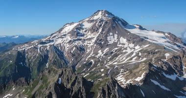
Located in the central Alaska Range, Denali National Park and Preserve encompasses 6 million acres of parkland and wilderness preserve with Denali as the centerpiece standing at 20,310 feet in elevation and visible for nearly 100 miles in every direction on a clear day. Denali, the highest point in North America, has been attracting visitors and climbers of all kinds since the Park's inception in 1917 when a 9,468 square mile boreal forest was designated with its original name of Mt. McKinley National Park, the first park under the newly established National Park Service. Towering 18,000 feet above the adjacent lowlands, the mountain's dramatic relief, and unique wilderness help shape the foundation making up the cultural landscapes of Denali National Park and Preserve that are unlike any other in the United States. It is a land of rugged contrasts with a long, rich history of native settlement and historical significance in the world of climbing and exploration as one of the "Seven Summits" of the world.
By entering the Park as visitors and climbers, it is our responsibility to respect the rich cultural and ecological history of the Park and act as stewards in the preservation of this unique and fragile environment. As climbers, we spend a great deal of time, effort, and resources to create a successful and memorable mountain experience. Equally important to the gear list, physical endurance, and mountaineering skills required to undertake a Denali expedition is an understanding of the history behind the environment with which we will so intimately interact. It is a privilege to be able to challenge ourselves and find enjoyment amongst these amazing landscapes. We encourage you to explore the below topics in preparation for your climb.
What is a Cultural Landscape?
A cultural landscape is a geographic area, including both cultural and natural resources and the wildlife or domestic animals therein, associated with a historic event, activity, or person, or exhibiting other cultural or aesthetic values.
References:
www.nps.gov/dena
www.nps.gov/dena/learn
Denali National Park and Preserve encompasses the heart of the Alaska Range in interior Alaska. It is home to North America's tallest mountain, extensive mountain glaciers, tight river canyons, broad braided river valleys, sweeping tundra, robust populations of large wildlife, one of the oldest cultural histories documented in North America, and unique paleontological resources. In 1980, over 4 million acres were added to the Park through the passage of Alaska National Interest Land Conservation Act (ANILCA) bringing over 6 million acres of wild lands under protection to preserve extensive, unaltered ecosystems in their natural state. In addition, most of the original Park was designated as the Denali Wilderness adding 2,124,783 acres to the National Wilderness Preservation System.
Denali Wilderness
The Alaska Range is a mountainous expanse running through the entire park, strongly influencing the park's ecosystems. The east-west trending crest of the Alaska Range creates a dramatic climate gradient with a relatively dry subarctic interior type climate on the north side, and a wetter, more moderate maritime influence on the south side. Vegetation in the park depends on the altitude.
Did you know?
The east-west trending crest of the Alaska Range creates a dramatic climate gradient with a relatively dry subarctic interior type climate on the north side, and a wetter, more moderate maritime type climate on the south side. This, along with elevation, greatly influences the vegetation in the Park.
The landscape is predominantly forested at elevations less than 2,500 feet (760 meters), with scrub vegetation and spruce woodland extending into the alpine zone from approximately 2,500 – 3,500 feet (760 to 1,070 meters) and low tundra in the alpine zone starting at approximately 3,500 feet (1,070 meters). This tree line limit causes most of the park to be a vast expanse of tundra. In the lowland areas of the park, such as the western sections surrounding Wonder Lake, spruces and willows dominate the forest. Most trees and shrubs do not reach full size due to unfavorable climate and thin soils. There are three types of forest in the park: from lowest to highest, they are low brush bog, bottomland spruce-poplar forest, upland spruce-hardwood forest. The forest grows in a mosaic, due to periodic fires.
In the tundra of the park, layers of topsoil collect on rotten fragmented rock moved by thousands of years of glacial activity. Mosses, ferns, grasses, and fungi grow on the topsoil. In areas of muskeg, tussocks form and may collect algae. The term 'muskeg' includes spongy waterlogged tussocks as well as deep pools of water covered by solid-looking moss. Wild blueberries and soap berries thrive in the tundra and provide the bears of Denali with the main part of their diet.

(Photo: NPS, Nathan Kostegian)
Uniquely Accessible Wilderness
The Denali Wilderness has a 92-mile road cutting through it. This is a uniquely accessible wilderness by Alaska standards; no other park in Alaska has the same combination of Congressionally-designated Wilderness and road access.
The Emerald Halo:

(Photo: NPS)

(Graphic: www.alaskaborealcanopy.com)
Denali is located in the northern boreal forest biome also known as the taiga or "emerald halo." The boreal forest is a circumpolar band of deep green that stretches through most of Alaska, Canada, Newfoundland, Scandinavia and Russia. Spanning 6.5 million square miles it's the largest intact forest in the world! Approximately one third or 2.3 million square miles of this forest stretches across interior Alaska and Denali National Park from the tree line south of the Brooks Range to the Chugach Mountains extending through Canada to the Atlantic in North America. Much of the park and preserve's boreal forest, or taiga, lies in valleys along the rivers.
It's an environment that experiences seasonal climate extremes, from -50˚F (-45˚C) in winter to 90˚F (32˚C) during the brief boreal summer. All resident life, from large mammals to insects and flora to fungi in the boreal forest have developed strategies and behavior to survive and flourish in these extreme environment changes.
Environment References:
www.nps.gov/dena/learn
www.nps.gov/articles/aps-v5-i1-c2.htm
www.alaskaborealcanopy.com www.denali.org/denalis-natural-history
www.nps.gov/akso/nature/science
dnr.alaska.gov/parks
Plant Life and Wildlife
Plant Life
More than 750 species of vascular plants grace the landscape, along with approximately an equal number of nonvascular plant species, and consist of trees and shrubs, forbs, horsetails, ferns, grasses, lichens, mosses and liverworts.
Alaska stands between Asia and North America and has been predominantly associated with the biota of northeastern Asia as opposed to that of North America. This is because the periodic formation of continental ice sheets thousands of feet thick (which covered most of Canada and parts of the northern continental U.S.), has separated Alaska from continental North America on many occasions. At the same time, the exposure of the Bering Land Bridge allowed plants and animals a wide dispersal corridor into Alaska from northern Asia. For this reason, many of the plant species of Denali occur in Alaska and northern Asia, but not elsewhere in North America.
Unique Plant Life
Many of the plant species of Denali National Park and Preserve occur in Alaska and Northern Asia, but not elsewhere in North America. This is due to the isolation of Alaska by the continental ice sheet and corridor created by the Bering Land Bridge that allowed plants and animals to migrate into Alaska from northeastern Asia.
-
Trees: Trees dominate the landscape in many lowland areas of the park, but there are only a handful of tree species that are able to grow and reproduce naturally this far north. There are eight species of trees that occur in Denali National Park. Three of these are coniferous (cone-producing) plants from the pine family (black spruce, white spruce and larch) and the other five are flowering plants from the willow and birch plant families (quaking aspen, balsam poplar, black cottonwood, paper birch and Alaska birch). (Photo: NPS, Katie Thoresen)

-
Shrubs & Dwarf Shrubs: Shrubs tend to occur most abundantly in subalpine regions where trees are less common. There are a few species of shrubs that occur above the elevation where trees are absent from the landscape, even at elevations up to 5,000 feet. There are fifty species of shrubs representing 10 different plant families that occur in the Park. The willow (Salicaceae) and heath (Ericaceae) families contribute the most species of shrubs to our flora, with 17 and 11 species respectively. Other plant families that are represented by shrubs in our flora are the Rose, Birch, Currant, Honeysuckle, Dogwood, Oleaster, Cypress, and Bayberry families. (Photo: Vickie Hendersen Art)

-
Forbs: Forbs are herbaceous flowering plant species. This category includes those plant species people think of as "wildflowers" such as goldenrod, gentian, fireweed, forget-me-not, larkspur, lupine, monkshood, poppies, and violets. This is the most species-rich group of plants in the Denali National Park flora, including about 450 species of plants from 54 families of flowering plants. (Photo: Ron Niebrugge)

-
Horsetails: There are seven species of horsetails that occur in the Park. These plants bear a distinctive cone-like "strobilus" that contains the spores and often form lush green canopies up to a foot or more high in sandy river flats across Denali during the spring and early summer. (Photo: NPS)

-
Ferns: This is an evolutionarily ancient and very diverse group of plants which is comprised of vascular plants that do not produce seeds, but instead reproduce and are dispersed through spores. The most species-rich fern family in the Denali flora is the Wood fern family (Dryopteridaceae; 13 species), followed by the Maidenhair fern family (Pteridaceae; 3 species). (Photo: DenaliNationalParkperiod4.weebly.com)

-
Grasses: Botanists call grasses and other grass-like plants "graminoids." Graminoid species are very ecologically diverse and very well represented in Denali's wetland flora. These plants often form the defining element of wetland plant communities – the familiar wet sedge meadow that lines the margins around ponds and in swampy openings within the boreal forest, although they are not restricted to marshy and wet sites in the Park. (Photo: NPS)

-
Lichens: Mosses and lichens (along with liverworts), although small, are a major component of Denali's plant life. They comprise about half of the diversity with over 800 species and provide many important ecological functions. They cover the ground in many areas of the park, from soggy wetlands to the rocky alpine. Lichens are very important components of subarctic and arctic ecosystems due to their role in weathering of rock and minerals and their contribution of nitrogen and other nutrients to the soil. (Photo: NPS)

-
Mosses and Liverworts: Mosses and liverworts (along with lichens), although small, are a major component of Denali's plant life. These are small "cryptogamous" plants that do not have true roots, leaves or stems. The deep layer of moss that forms in the floor of boreal forests and bogs has profound influences on the physical and biological characteristics of these sites. For example, the growth of permafrost under the insulative blanket provided by feather mosses in spruce forests results in radical changes in the soil temperature and moisture of a site, the amount of available nutrients, and the ability of vascular plants to become established, over time. (Photo: NPS)

Wildlife
Denali National Park and Preserve's abundant and diverse wildlife are just as famous as its tallest mountain. Although the park's namesake is a mountain, Denali was the first national park created to protect wildlife. Now, this park is home to 39 species of mammals, 169 species of birds, 15 species of fish, and 1 lonely species of amphibian. Our time spent in the park consists of high alpine areas with sparse wildlife, but climbers will encounter ravens at various camps along the West Buttress route as high as 17,000 feet.
Mammals:
There are 39 species of documented mammals that range in size from tiny shrews that can weigh as little as a penny to enormous moose that can weigh over 1,200 pounds. Five mammals in particular capture visitor's imaginations and are so popular they are now referred to as the "big five." The assortment includes moose, caribou, Dall sheep, wolves, and grizzly bears.
-
Moose: The moose is the largest member of the deer family and their habitat mostly consists of river bottoms and willow patches. Their antlers can reach an incredible 80 inches in size. Moose are an important part of life for subsistence users in Alaska. (Photo: NPS, Kent Miller)

-
Caribou: The caribou can be found in a variety of habitats that include both the treeless tundra and mountains, and boreal forests. They are the only deer family member in which both the male and female have antlers. A newborn calf walks within a few hours and can outrun a person at just 3 days old. (Photo: NPS, Layne Adams)

-
Dall Sheep: Denali's most well-known mammal, the Dall Sheep, is monitored closely and occupies the alpine ridges, meadows and steep, craggy slopes. It was the Dall Sheep that first brought Charles Sheldon to the Denali area and later inspired him to lead the effort in protecting the Denali wilderness. (Photo: NPS, Lian Law)

-
Wolves: The Park's wolves have been studied by researchers since 1939 and have a widespread territory. Their colors vary from black to white, but gray is the most common. Their average pack size is 4 – 5 wolves and each pack can cover anywhere from 200 to 600 square miles. (Photo: NPS)

-
Grizzly Bears: Grizzly bears are typically found on the open tundra, but may be found anywhere. They retreat to their winter dens in October which are often at higher elevations, and emerge in April to early May. (Photo: NPS, Ken Conger)

Did you know?
Denali is home to both black bears and grizzly (brown) bears. Black bears inhabit the forested areas of the Park, while grizzly bears mainly live on the open tundra. Almost all bears seen by visitors along the Park Road are grizzlies.
Birds:
Denali has over 160 species of birds that call the park home during the summer months. Many birds that breed in Denali migrate long distances to reach the park, some from as far away as South America, Asia, and Africa. Great numbers of sandhill cranes and trumpeter swans create a stirring sight as they migrate in skeins above Denali. Ravens can be found at higher elevations and it is not unusual for mountain climbers to see ravens at altitudes exceeding 17,000 feet. They treat people much like wolves or bears being quick to pick up our scraps. We always make the effort to diligently manage our trash while on the mountain to prevent habituating the wildlife to our presence and carry out all trash when we leave the mountain.
-
Golden Eagle: The Golden Eagle is one of North America's largest aerial predators, and one of many predatory birds in the Park (including the well-known Bald Eagle). The abundance of cliffs and rock outcroppings for nest sites, as well as the diversity of prey, make the northern foothills of the Alaska Range an ideal habitat for this bird. (Photo: NPS, David Restivo)

-
Osprey: The fish-eating osprey are attracted to the park's myriad of lakes and streams. (Photo: NPS)

-
Great Gray Owl: The Great Gray Owl is rare and nomadic traveling long distances in search of food. Most of the Park's owls are year round residents. (Photo: NPS, Tim Rains)

-
Sandhill Crane: Thousands of sandhill cranes migrate to Alaska during the spring from their wintering grounds in Texas or northern New Mexico for breeding season. Sandhills are omnivores and have powerful bills they use to dig and probe for insects and worms. They retreat south again as cold weather returns and this food source becomes scarce. (Photo: Denali.org)

Amphibians & Reptiles:
There are no reptiles found this far north, but there is a single species of amphibian that is adapted for life in the cold. The Wood Frog, the only amphibian in interior Alaska, freezes solid to survive the winter then thaws back to life in the spring.
-
Wood Frog: The Wood frog is the only amphibian that inhabits the Park and interior Alaska, and that is adapted for life in the cold. (Photo: DenaliNationalParkperiod4.weebly.com)

The Wood Frog is the only amphibian in interior Alaska and freezes solid to survive the winter then thaws back to life in the spring.
Environment References:
www.nps.gov/dena/learn
www.nps.gov/articles/aps-v5-i1-c2.htm
www.alaskaborealcanopy.com www.denali.org/denalis-natural-history
www.nps.gov/akso/nature/science
dnr.alaska.gov/parks
Climate
Denali experiences a wide range of meteorological conditions. At 20,310 feet above sea level, it is the highest point in North America and experiences some of the most severe weather in the world. Many consider Denali to be the world's coldest mountain because of its combination of high elevation and its subarctic location at 63 degrees north latitude. Mt. Everest (29,028 feet) is the world's highest point above sea level, but it is at the same latitude (28 degrees north) as Florida's Walt Disney World. Denali sits 2,400 miles further north making for an enormous difference in temperature.

(Photo: Pete Van Deventer)
Denali is so massive that it generates its own weather; much the way a huge boulder submerged in a river creates whitewater rapids. All mountains deflect air masses and influence local conditions, but Denali rises so abruptly and so high that this effect is more dramatic here than perhaps anywhere else on Earth. Storms barrel in from the Gulf of Alaska and the Bering Sea and collide with Denali's towering mass. Weather can quickly change from sunny and clear to blizzard conditions with fierce winds, intense cold, and heavy snowfall. Climbers must understand and pay close attention to warning signs of changing weather, and be prepared to react accordingly.

(Photo: Adam Knoff)
There are two distinct climates in the Park, separated by the Alaska Range. The north and south side of the Alaskan Range have a completely different climate and they differ not only in physical measurements, but also in the types of vegetation and landscape features they produce. The Gulf of Alaska carries moisture to the south side, but the mountains block water to the north side. The south has transitional maritime continental climates with moister, cooler summers and warmer winters that bring considerable rain and snow. On the north side, an area of Arctic high pressure generates drier climate conditions with huge temperature fluctuations and low precipitation.
World's Coldest Mountain
Many consider Denali to be the world's coldest mountain because of its combination of high elevation and its subarctic location at 63 degrees north latitude. Mt. Everest (29,028 feet) is the world's highest point above sea level, but it is at the same latitude (28 degrees north) as Florida's Walt Disney World. Denali is 2,400 miles farther north making an enormous difference in temperature.
Climate References:
www.nps.gov/dena/learn/nature/weather
www.nps.gov/articles/denali
www.nps.gov/articles/aps-v5-i1-c2
Article References:
www.nps.gov/dena
www.nps.gov/subjects/centennial

(Photo: NPS, Kent Miller)
-
Formation & Growth
Denali reigns in lofty isolation over the Alaska Range, the 600-mile arc of mountains that divides south-central Alaska from the interior plateau. Its life as a mountain range began some 65 million years ago as the result of the Denali Fault, North America's largest crustal break.
Standing at 20,310 feet in elevation, Denali has a topographic prominence of 20,157 feet, while its topographic relief is over 18,000 feet when measured from the base which is greater than the relief of Mt. Everest. Denali is continuously being pushed up and grows approximately 1 millimeter per year due to the continued convergence of the North American and Pacific Plates. It remains like a resistant sentinel above the others which wear down faster through the eons of freezing, thawing, and glaciers grinding and scraping. Although surrounded by many glacier-clad mountains of similar grandeur, Denali, which is primarily made of granite, resists weathering much better than its sedimentary (shale, limestone and sandstone) neighbors allowing it to remain higher than the surrounding mountains. At 56 million years old, Denali is also much younger than most of the surrounding mountains, which vary in age from 100 to 400 or more million years old. That sedimentary neighborhood is a long history of geologic puzzle pieces thrown together to form Denali National Park and Preserve, and most of Alaska, as we know it.
-
Denali at a Glance
Elevation: 20,310 ft (South Crest)
Subsidiary Peaks: North Summit (19,470 ft)
Relief: 18,000 ft
Prominence: 20,157 ft
Range: Alaska Range
Composition: Granite and slate
Age: 56 Million years
What is the difference between Topographic Relief and Topographic Prominence?
Topographic Relief is the elevation of a summit relative to the surrounding terrain in a defined area; Topographic Prominence is the elevation of a summit relative to the highest point to which one must descend before re-ascending to a higher summit on a contiguous landmass.
In the process of plate tectonics, (the Pacific plate is diving beneath Alaska, or the North American Plate) land surfaces in Alaska are continually compressed and folded, which pushes up Denali, as well as the rest of the mountains in the Alaska Range. The Pacific plate has been acting like a conveyor belt for hundreds of millions of years, bringing bits of islands, ocean floor, and slivers of other continents northward to form accretionary terranes, which are pieced together like a jigsaw puzzle.
A Brief Geologic History
During the last 100 million years, uplifting caused by buckling from continuous tectonic collision led to the creation of the present-day topography of the Alaska Range. The following is a brief geologic history of the formation of Denali and the surrounding area.

(Photo: NPS, Kent Miller)
- 300 to 500 million years ago: The oldest rocks in the park, collectively called the Yukon-Tanana terrane, were ocean sediments deposited in shallow seas during the Paleozoic era.
- 100 to 300 million years ago: Later in the Paleozoic and into the Early Mesozoic, other terranes, fragments of the larger continental plates, migrated north on the Pacific Plate and attached to the Yukon-Tanana terrane, creating the current jigsaw puzzle of rocks from many depositional environments.
- 70 million years ago: Alternating warm, near-tropical conditions and cooler, drier periods enhanced erosion and deposition in sedimentary basins such as the Cantwell, where dinosaurs walked among ancestral lakes, braided streams, and alluvial fans.
- 56 million years ago: Molten magma solidified deep beneath central Alaska, volcanic activity (eruptions at the surface) was also occurring in the Park, and produced red, yellow and brown basalts, rhyolites, and other volcanic rocks. These rocks can be seen along the Park Road, particularly at Polychrome Pass, named for the colorful volcanic rocks exposed there.
- 38 million years ago: Another period of volcanic activity resulted in the basalts and andesite found exposed at Mt. Galen, and along the Park Road at the west end of Eielson Bluffs. Similar to Denali, another granitic blob crystallized at depth beneath the surface to become Mt. Foraker, the second tallest peak in the park at 17,400 feet (5303 meters).
The oldest terrane and rocks in the park are found near the park entrance, and are called the Yukon-Tanana rocks. These are shallow sediments with volcanic flows and intrusions (molten injections of rock) that formed in a very young Alaska, about 400 million years ago.
Generally following the Alaska Range, the Denali Fault system arcs East-West through the park (and most of the state) for 720 miles (1,200 kilometers). Portions of the fault trace are visible within the Park at Bull River divide, Easy Pass, and other locations. Because the Pacific Plate continues to collide with and slide beneath Alaska, the buckling and uplift continues creating a seismically active area around Denali. In November of 2002, a magnitude 7.9 earthquake centered on the Denali Fault east of the Park ruptured the surface with up to 30 feet (9 meters) of strike-slip offset.
Accretionary Terrane
Terrane is a term used to describe any rock formation(s) or area in which a particular formation or group of rocks is predominant.
Accreted terranes are created as a result of a tectonic collision and sediments and crust fragments layer or suture together to form land mass.
References:
www.nps.gov/dena/learn/nature
www.nps.gov/articles/denali.htm
www.nps.gov/articles/aps-v5-i1-c2.htm
https://www.nps.gov/dena/learn/nature/denali
pubs.usgs.gov/pp/p1386k/pdf/10_1386K_alaskarange.pdf
Article References:
www.nps.gov/dena
www.nps.gov/subjects/centennial
Glacial History

(Graphic: NPS)
During the past two million years, Denali Park and Preserve's history has been characterized by repeated advances and retreats of a massive ice sheet. Over half of the Park (Alaska Range and south) was intermittently covered by an extension of the ice sheet in Canada. During glacial maxima, valley glaciers dominated the northern foothills of the Alaska Range and ice lobes extended into the lowlands. As many as seven major glacial advances and several minor advance-retreat sequences have been identified on the north side of the range. Landforms such as sculpted valleys, terraces, moraines, and kettle ponds are common in the northern river valleys.
Denali's Glaciers
Glacial ice has retreated significantly since the Pleistocene. Today, glaciers and/or perennial snow fields cover approximately 1 million acres, or one sixth, of the 6 million acres of Denali National Park and Preserve with the most extensive glaciers on the southeastern side of the range due to the heavier snowfalls there delivered from Gulf of Alaska weather systems.
The heavily glaciated Alaska Range consists of 10 adjacent and discrete mountain ranges that extend in an arc more than 600 miles (750 kilometers) long with a total glacier area of approximately 5,300 square miles (13,900 square kilometers). There are several thousand glaciers ranging in size from tiny, unnamed cirque glaciers to very large valley glaciers with lengths reaching over 40 miles. Denali is contained in a range segment known as the Mt. McKinley-Mt. Foraker segment that is approximately 170 miles (275 kilometers) long and 50 miles (80 kilometers) wide.
The most massive glaciers in the park drain snow and ice from the flanks of Denali. There are over 400 glaciers in the Park and at least 40 are named glaciers that flow from heights as high as 19,000 feet and descend to elevations as low as 800 feet above sea level. The Peters Glacier flows from the north and northwest portion of the mountain, whereas the Kahiltna Glacier is situated on the southwestern side of Denali and shares the southern slopes with an arm of the Ruth Glacier. The Ruth Glacier primarily occupies the southeast side of Denali.
The most massive glaciers in the park drain snow and ice from the flanks of Denali. There are over 400 unnamed glaciers and at least 40 named glaciers that flow from heights as high as 19,000 feet and descend to elevations as low as 800 feet above sea level.
From the very top of Denali, the Harper Glacier dumps snow and ice into the upper reaches of the Muldrow Glacier, which carries snow and ice off Denali's northeast slopes. Of these glacial systems, the Ruth, Kahiltna and Muldrow Glaciers are the longest glaciers in the park; each is more than 30 miles long. The Kahiltna Glacier, which is not only the longest glacier in the park but also in the entire Alaska Range, is 44 miles in length. Some other prominent glaciers in the Park include the Muldrow, Tokositna, Eldridge, Traleika, and Yentna.
References:
www.nps.gov/articles/aps-v5-i1-c2.htm
www.nps.gov/dena/learn/nature/glaciers.htm
pubs.usgs.gov/pp/p1386k/pdf/10_1386K_alaskarange.pdf
What is a Glacier
A glacier is a mass of ice that is large enough and heavy enough to flow, like a very thick fluid. Glaciers form as snow accumulates high on the mountain, where temperatures are too cold even in the summer for all of the snow to melt before winter sets in again. This is called the accumulation zone, and is typically covered in snow year-round. Over the years, the accumulated snow packs down under its own weight, becoming denser and denser, until it becomes ice.

In many places, the slopes of the mountain are steep enough that these massive ice fields begin to flow downhill under the force of gravity at an average of up to 7 inches per day. Glaciers in Alaska can move significantly faster at several feet per day (the Columbia Glacier in Alaska is one of the fastest moving in the world and moved over 90 feet per day at it's maximum flow). The glacier is in constant motion as the ice in the accumulation zone flows down to lower altitudes into what is called the ablation zone. The ablation zone is the lower part of the glacier where more snow is lost than accumulates.
Glaciers slide across the ground at their base, tearing and grinding rocks out of the mountain as they move, and they twist and deform under their own weight. Avalanches and erosion deposit more rocks on the surface of the glacier, and eventually, the glacier becomes a thick, frozen mixture of ice and rock.

As the glacier flows down the mountainside it eventually reaches an elevation where temperatures are warm enough for it to melt. At this point, the glacier becomes a river and a source of drinking water, irrigation, and hydroelectric power for natural and human communities downstream. Meanwhile, snow continues to fall near the top of the mountain, replenishing the glacier. When the glacier melts, all of the rock embedded in it melts out of the ice and into the riverbed. The river gradually tumbles the rock downstream, carrying it toward the ocean. The river is constantly rearranging the rock and changing course around it, always seeking the easiest path through the debris. This is why glacial riverbeds are wide and rocky, with the river itself braided into constantly-changing channels and sub-channels somewhere down the middle. This on-going process of rocks left behind by glaciers accumulating in rivers is known as aggradation.
Glaciers in Motion
The Columbia Glacier in Alaska is one of the fastest moving glaciers in the world with a recorded rate of 98 feet per day at its maximum flow.
References:
www.glaciers.pdx.edu
www.nps.gov/dena/learn/nature
Anatomy of a Glacier
Glaciers can vary widely in size and shape, but generally display the same framework. The blue outline in the image on the right marks the edges of the glacier, and the letters pointed out on the photo mark out different glacier features.
-
A) Crevasses are cracks and breaks in the glacier ice, formed as the ice moves unevenly over the terrain and valley floors. The circle around "A" shows a magnified view of a small portion of the crevasses.
B) Rock debris can cover the lower portions of a glacier as a result of rockfall from nearby slopes or rock formations. Rock layers can help insulate the glacier's ice from melting and are believed to contribute to an advance of a glacier for a time after the rockfall.
C) Terminus, or end, of the glacier.
D) Water from melting glacial ice leaving the terminus of the glacier. Streams flowing from glaciers are clouded with fine sediment, called glacial flour, created by the glacier grinding its rocky bed. The glacial flour gives the water a milky color.
E) Outwash Plain, filled with sediment, rocks, and other debris left behind behind the retreating glacier. Outwash plains are further shaped by the glacial meltwater streams, forming braided river beds through a process called aggradation.
F) Terminal Moraine, a large ridge-like formation of rocky debris left behind by the terminus of the glacier as it retreats. Terminal moraines like the one indicated here mark places in the valley that the glacier extended to in the past.
G) Glacial ponds can form if glacier ice broken off the main glacier melts and the water is captured behind a moraine. Terminal moraines can also dam the valley, causing melt water to pool.
H) Lateral moraines are debris ridges forming along the edges of the glacier instead of at the terminus.
-
 Glacier Anatomy.
(Photo: NPS)
50,000 Billion Gallons
Washington and Alaska are the only two states in the United States which get a significant percentage of their water supplies from glacial sources. In total, Alaska's glaciers empty over 50,000 billion gallons of water into streams and rivers every summer.

(Photo: Brent Okita)
References:
www.glaciers.pdx.edu
Types of Glaciers

(Graphic: www.glaciers.pdx.edu)
Valley Glaciers: Most of the glaciers on Denali and in the Park are known as valley glaciers. These glaciers are confined to a valley (usually a former stream valley) with some extending over 30 miles in length.
Cirque Glaciers: The smallest glaciers occupy a bowl-shaped basin at the head of a mountain valley. If a cirque glacier advances far enough, it may become a valley glacier. Additionally, a valley glacier retreats enough that it is within the cirque, it is a cirque glacier again. Cirque glaciers are usually the remnants of much larger valley glaciers.
Continental Glacier: Another type of glacier, called a continental glacier, is a large ice sheet that covers thousands of square kilometers and is found only in high latitudes (Greenland / Antarctica) and are thousands of square kilometers in area and thousands of meters thick. These tend to smooth out the landscapes.
-
 Kahiltna Glacier is the longest glacier in the Park and in the Alaska Range at 44 miles long. The Southeast Fork of the Kahiltna Glacier serves as the site of a seasonal air strip and base camp for climbers attempting several routes, including the West Buttress route.
(Photo: swisseduc.ch) -
 The Southeast Fork of the Kahiltna Glacier is the site of the seasonal airstrip and base camp for Denali at approximately 7,200 feet. Base camp becomes a hub of activity with climbers coming and going at most hours of the day during climbing season.
(Photo: RMI) -
 The Northeast Fork of the Kahiltna Glacier seen here in the middle of the photo provides access to the popular, but more technical, West Rib and Cassin routes. It is also known as the "Valley of Death" because it is narrow, heavily crevassed and avalanches from the surrounding Kahiltna Peaks. The rarely visited East Fork provides access to the South Buttress.
(Photo: Summitpost.org)
-
 Harper Glacier originates on Denali at more than 19,000 feet high between the North Peak and South Peak. It flows down between Karstens Ridge and Taylor Spur eventually into the Great Icefall and becoming the Muldrow Glacier. Seen in this photo just right of center.
(Photo: Summitpost.org) -
 Ruth Glacier is the thickest glacier in the Park measured at over 3,500 feet thick and moves at a rate of 3.3 feet per day. It is 1-mile-wide and flows through the great Ruth Gorge at the foot of 5,000-foot-high granite cliffs.
(Photo: Summitpost.org) -
 Muldrow Glacier originates from the Great Icefall of the Harper Glacier on the east side of Denali. The Muldrow Glacier route was used by the first "Sourdough" climbers to summit Denali in 1913 and is still used today by climbers attempting to summit from the north side.
(Photo: Denaliair.com)
References:
www.glaciers.pdx.edu
http://www.nps.gov/dena/getinvolved
www.us-parks.com/denali-national-park-and-preserve/glaciers-glacial-features.html
Other Glacier Features
Sun Cups
Sun cups are shallow "cup" like hollows in the snow's surface that are created through exposure to strong sunshine. While sun cups can be created through sublimation, they can also form due to melting. They are typically smaller than penitentes and can occur at lower elevations.

(Photo: Brent Okita)
Bergschrund
A bergschrund is a large, often deep, crevasse that forms at the upper end of a glacier. Sometimes a bergschrund forms between a lower portion of active glacier and an upper portion that has stopped flowing and become stagnant ice or snow. Denali also has bergschrunds where the glaciers break off from the upper flanks and, depending on the time of year and route conditions, can be seen up close on your summit climbs.

(Photo: John Race)
Serac
Seracs are large blocks or columns of glacial ice created when crevasses cross each other. The large pinnacles of ice can collapse unexpectedly, which combined with the broken surface terrain, makes seracs very dangerous for climbers.

(Photo: Robby Young)
Crevasse
Crevasses are cracks that occur in the ice of all glaciers due to tensions caused by differences in velocity throughout the body of the glacier, and the bedrock formation deep under the glacier that the glacier flows over. Crevasses can be hidden by snow or debris. Snow that fills crevasses during the winter melts out from below, leaving thin snowbridges over the cracks in early summer that pose a real danger to glacier travel because of their inherent weakness and instability.
Moulin
Moulins, also known as glacier wells, are a nearly vertical well-like shaft within a glacier which water enters from the surface and are the typical cause of the formation of a glacier cave. They are part of the internal "plumbing" system of a glacier that carries meltwater from the surface down to the bottom of the glacier or into a common crevasse formation.

(Photo: Library of Congress)
References:
www.glaciers.pdx.edu
Article References:
www.nps.gov/dena
www.nps.gov/subjects/centennial
Natural History & Cultural Heritage
For at least the last 11,000 years, people hunted, camped and lived in the area now known as Denali National Park & Preserve resulting in archaeological sites, historic structures, cultural landscapes and associated features, objects, and traditional cultural properties that are contributing elements to wilderness. Historic structures and other historic properties, such as old roads, mines, mills, cabins, and artifacts embody the cultural heritage of the park and contribute to both its unique landscape and wilderness.
The park represents a rare place where human influence has never fundamentally altered the natural ecosystems. From the end of the last ice age until roughly 100 years ago, the upland areas were occupied seasonally by bands of hunters and gatherers who lived the rest of the year in forested areas near the larger rivers. For many Alaska Natives and rural people, these wilderness-designated areas have been and continue to be essential areas for subsistence hunting, fishing, gathering, and traditional knowledge.
Early Residents & Visitors
Two of the oldest known archaeology sites in North America – Teklanika West and the Bull River II sites – are in Denali. These sites date from 12,500 to just over 13,000 years old.
Native People:
Based on the archeological record, human populations appear to have existed within the present-day park boundaries for more than 7,000 years. The first known evidence of human occupation, a piece of charcoal from a bluff near the Teklanika River, has been radiocarbon dated to 7,130 ± 98 B.P.9 Humans appear to have stayed at that site, off and on, for more than 5,500 years. More recent prehistoric sites are found at Lake Minchumina, just northwest of the park, which are between 1,000 and 2,600 years old. Archeologists thus far have recorded 84 prehistoric or protohistoric sites in the park and preserve. Two of the oldest known archaeology sites in North America - Teklanika West and the Bull River II Sites - are in Denali. These sites date from 12,500 to just over 13,000 years old. These sites are important as they provide some of the oldest physical evidence of when prehistoric people migrated to and inhabited this continent during the last Ice Age.
Because of their lack of cultural context, however, archeologists can only guess at the age of most of these artifacts and at the functions they served. There is considerable dispute about the cultural tradition of these early peoples. Some researchers consider the development of a recognizable Athabaskan cultural pattern began roughly 6,000 years ago. Others, however, feel that the earliest peoples were called Amerinds, while the separate Athabaskan tradition represents a later migration. Regardless of when they began, Athabaskan culture and ethnic identity has been traced back 1,500 years or more according to linguistic evidence, and about 1,000 years through their material culture.
For the past several hundred years, five groups of Athabaskan-speaking Indians have lived in the park and surrounding areas. These groups include the Ahtna, the Dena'ina, the Upper Kuskokwim (Kolchan), the Lower Tanana, and the Koyukon. Within Denali, there are more than 100 documented native place names, which demonstrate that Denali's wilderness has been inhabited for thousands of years. Place names and their associated stories are important not only as a tool of understanding traditional land use, but also in preserving the complex knowledge of Alaska Native peoples who have inhabited this place for centuries.
Non-Native Explorers:

(Photo: NPS, Candy Waugaman Collection)

(Photo: Prindle Collection, #526, US Geological Survey)
Few non-Natives visited the Mt. McKinley (Denali) region—either north or south of the Alaska Range—before the 1890s. The first visitors were prospectors, followed by both civilian and military exploration parties.
Non-native exploration of the area surrounding the present-day park unit was slow in coming, primarily because it was distant from the coast and remote from easily navigable rivers. The Russians, who held a nominal jurisdiction over present-day Alaska from 1741 to 1867, never penetrated within 50 miles of the park unit. And while it is indisputable that virtually all of Alaska was being either directly or indirectly influenced by European-based explorers, the reality is that non-Natives during this period impacted the lives of those who either occupied or used the lands in Denali's shadow less than other groups who lived along the coast or along major inland trading routes. By all accounts, non-Natives' only direct influence on the area during this time was a series of uncoordinated attempts to apply names to the area's mountains. William Dall, who took part in the ill-fated Western Union Telegraph Expedition of 1865-67, proposed that the mountain chain that divided the Yukon River from the coastal country to the south be named the "Alaskan Range." Locals, over time, shortened his suggestion to the Alaska Range, a name that still stands today.
The purchase of Russian America by the U.S. government, at first, had few immediate impacts on Alaska outside of Sitka. For more than a decade afterward, few Americans ventured north, but in 1880 a major gold strike took place along Gastineau Channel, and Juneau erupted into life. Soon afterward, more gold was discovered at nearby Douglas, and before long, an increasing number of prospectors headed north and began fanning across the north country. Most prospectors were far less fortunate. As a group, however, they were willing to go virtually anywhere in search of the elusive yellow metal. A party led by Frank Densmore, for example, crossed from the Tanana to the Kuskokwim drainage in 1889 and, though he found no Eldorado along the way, his enthusiasm over the huge, unnamed peak to the southeast prompted his peers to call it "Densmore's Mountain."
Seven years after Densmore's trek, another prospector, William A. Dickey, was one of several who approached the mountain from the south. He gave the mountain a new name—Mt. McKinley—and justified it because both he and McKinley were avowed proponents of a gold standard, and McKinley's nomination as the 1896 Republican presidential candidate "was the first news we received on our way out of that wonderful wilderness." Dickey's sojourn up the Susitna River took place the same year as a huge gold strike in the Klondike. That event reverberated throughout the north country and caught the attention of the US Geological Survey and the US Army who then conducted 5 different expeditions in 1898 and 1899 into the countryside surrounding Mt. McKinley (Denali). This would be followed by several more parties that also set out to survey and explore the interior of the Alaska Range. These groups were thought to have been the first to tread within the boundaries of Denali National Park and Preserve.
After the turn of the century, outsiders continued to venture closer to the mountain massif than they had previously, and in 1903 two parties made the first attempts to climb Denali. While both attempts were unsuccessful, the leaders of these parties left the area duly impressed by its scenic majesty, and one party found gold particles in a Kantishna Hills streambed. That discovery brought others into the area, and in 1905 a gold rush brought thousands of prospectors, primarily from Fairbanks and nearby points. Up until this time, the area surrounding Mt. McKinley (Denali) was being explored and developed in a way similar to most of the rest of Alaska. Because of its isolation from navigable waterways, European-based peoples had filtered into the area somewhat later than many other areas in Alaska. The recent gold rush, however, suggested that this area might soon develop to an even greater degree. This development at the turn of the century ushered in a new wave of visitors that would become the first advocates in forming Denali National Park and Preserve.
Multiple Identities
Non-Natives' only direct influence on the area around the turn of the century was a series of uncoordinated attempts to apply names to the area's mountains, particularly Denali.
It was first known as Densmore's Mountain after a gold prospecting party led by Frank Densmore became enthusiastic over the unnamed peak. Later, William A. Dickey named the mountain Mt. McKinley inspired by McKinley's nomination as the 1896 Republican presidential candidate at the time.
Cultural Heritage & Preservation
Denali maintains a strong commitment to preserve and interpret not only the expansive natural resources of the park, but also a rich collection of historic and prehistoric sites that provide a record of over 10,000 years of human settlement and activity in an area frequently considered today as an "untouched wilderness." In addition to the National Park Service's mission of protecting these resources, the National Historic Preservation Act (NHPA) of 1966 provides a legal framework of cultural resource preservation in national parks. The NHPA mandates that Federal agencies identify historic properties in their possession, and that those properties be considered prior to taking any actions which could harm them. In practice, this means that the Park is responsible for identifying and evaluating its historic properties. So far, the Park has several properties listed on the National Register such as Teklanika Archaeological District (1967), Mt. McKinley National Park Headquarters Historic District (1987), and Park Patrol Ranger Cabins. Many historic and archeological sites, such as the Park Road, Savage Camp, Wonder Lake Ranger Station, many prehistoric sites throughout the park, and the Old Eureka / Kantishna Historic Mining District have been determined eligible for the National Register.
Several other legal frameworks have been in place for decades that are applicable to wilderness and help support the protection of historic, archaeological and cultural resources. These include the Archaeological Resources Protection Act (ARPA), American Indian Religious Freedom Act (AIRFA), and the Native American Graves Protection and Repatriation Act (NAGPRA), as well as others intended to preserve our cultural heritage.
Preservation of "Untouched Wilderness"
Denali maintains a strong commitment to preserve and interpret not only the expansive natural resources of the park, but also a rich collection of historic and prehistoric sites that provide a record of over 10,000 years of human settlement and activity in an area frequently considered today as an "untouched wilderness."
Natural History & Cultural Heritage References:
www.nps.gov/dena/learn/historyculture
www.nps.gov/archeology
Article References:
www.nps.gov/dena
www.nps.gov/subjects/centennial
Crown Jewel Of The North: A Century Of Climbing & Administrative History
Administrative History
Administrative Beginnings

(Photo: NPS, Denali National Park & Preserve Museum Collection)
Virtually everyone who visited the north side of the Alaska Range around the turn of the century were on practical missions; the U.S. Geological Survey crews, for example, were asked to describe the area's topography and geology for a government publication, the Army expeditions were making a general reconnaissance, and the two parties that arrived in 1903 were there to climb Mt. McKinley, nothing more. However, the reports that they wrote consistently and effusively described two remarkable qualities about the area: its scenery and its wildlife. The magnificence and praise of the mountain massif was first recorded by Muldrow, Eldridge, and Herron in the late 1890s, and virtually everyone who came thereafter was similarly impressed.
Beginning in 1902, the area's diverse and plentiful wildlife was lauded and it was referred to as "the best game country in America." James Wickersham, an Alaska District Judge later elected as a delegate to Congress, was obviously impressed stating that "This forest ought to be withdrawn from disposal and preserved for the use of those who shall come after us to explore the highest and most royal of American mountains." For Wickersham, or any other Alaska official, to suggest a scenic land withdrawal in 1903 was a highly unusual move because conservation, as we know it today, was still in its embryonic stages and the already designated forest reserves were only marginally effective in stopping the ongoing desecration of the country's forested lands. Conservation was even less of a concern in remote Alaska. Driven by the potential riches of the quickly-developing area, Alaskans were in no mood to tolerate new federal land withdrawals with widespread protests that greeted President Roosevelt's closure of Alaska's coal lands in November 1906.
In the midst of this antagonistic atmosphere, Charles Sheldon came to Alaska in search of the gamelands north of the Alaska Range. He was a hunter-naturalist in the tradition of Theodore Roosevelt. He developed a deep interest in the study and preservation of mountain sheep and had traveled to Alaska to observe the relatively little-known Dall sheep in its natural habitat. He immersed himself in the studies of other mammal populations and the more he learned, the more he grew to appreciate the area. He noted that because of the "beauties of the country and of the variety of the game," the area "would make an ideal park and game preserve." The idea of a "Denali National Park" remained a fixture for Sheldon throughout the rest of his stay. He and Karstens, after that date, paid keen attention to the meandering wildlife in order to create park boundaries that might best protect them.
"Best Game Country in America"
Beginning in 1902, the area's diverse and plentiful wildlife was lauded and referred to as "the best game country in America." This would serve as the catalyst for Charles Sheldon who would spend a decade in the pursuit of protecting these resources and forming the beginnings of Denali National Park and Preserve.

(Photo: NPS, Karstens Library Collection)
Sheldon pitched the idea of a game preserve, but because Congress had a waning interest in conservation, Sheldon recognized that the idea would have to wait. As time went on, Sheldon and other like-minded individuals continued to refine the idea and, in the meantime, Sheldon gained a key Alaskan ally in James Wickersham, the former district judge in Fairbanks who became Alaska's non-voting delegate to Congress in 1909. In 1912, toward the end of Taft's term, Congress showed more interest in Alaska than it had since the Klondike days of the late 1890s and that year it passed Alaska's second Organic Act which made Alaska a full-fledged territory with an established legislature. This act also established an Alaska Railroad Commission which would seek to find a viable railroad route between Alaska's southern coast and the interior. Sheldon had mixed feelings about the railroad because it would make it far easier for tourists and nature-lovers of all kinds to visit the gamelands, but he was also concerned because that same railroad would ease access for market hunters whom, he feared, might easily wipe out the area's sheep, caribou, and other large game. In order to protect the cherished wildlife, they needed to convince Congress to pass a park bill, and in addition they needed to convince Congress to expend funds on park enforcement staff. And all of this needed to be done before railroad construction neared the boundaries of the newly established park. Sheldon pushed on and garnered support from Belmore Browne of the Camp Fire Club of America who had also been formulating his own proposal for preserving the Denali Landscape and was also familiar with the beauties of the Alaska Range. Thomas B. Riggs, head of the Alaska Engineering Commission—which was then constructing the railroad between Seward and Fairbanks—also saw the bill's benefits, noting that a national park would boost tourist travel along the line. Within Alaska, delegate Wickersham voiced his strong support for a park bill, recognizing that it would stimulate tourism to Alaska. Because Sheldon, Riggs, and Browne all knew the country well, and because all three men supported a park bill, they were the primary determinants of the park's boundaries.
Attention next moved to Congress. Wickersham, Browne, and Sheldon collaborated on the drafting of a park bill which was submitted to the House of Representatives on April 18, 1916. The bill continued to be the subject of much debate and went through several amendments and provisions until February 26, 1917 when President Woodrow Wilson signed the McKinley park bill officially creating Mt. McKinley National Park. What emerged from the legislative battle was a park that largely reflected the vision that Charles Sheldon and Harry Karstens had first developed almost a decade earlier.
The new national park, the first to be established after Congress had created the National Park Service, encompassed an area of almost 1.6 million acres and stretched nearly 100 miles from northeast to southwest, and was between 20 and 35 miles wide. Within those protected acres was North America's highest peak, a remarkable array of plant and animal habitat, and perhaps most important, it gave legal protection to vast expanses of habitat where various large mammals thrived. Given those remarkable resources, Congress stated that its primary intent in establishing the park was "the freest use of the said park for recreation purposes by the public and for the preservation of animals, birds, and fish and for the preservation of the natural curiosities and scenic beauties thereof."
A New National Park
The new national park, the first to be established after Congress had created the National Park Service, encompassed almost 1.6 million acres, stretched more than 100 miles from northeast to southwest, and was between 20 and 35 miles wide.
Park Expansion & Development

(Graphic: NPS)
By early 1920, funds were allotted to perform surveying to officially define the Park's boundaries. Harry Karstens was appointed as the first superintendent and would be pivotal in the introduction and development of the park headquarters, park road, game protection, early park expansions on the east side, and concession permits. Tourism in the park increased and by the 1930s concessioners had established themselves providing lodging and activities for tourists to experience the Park, and the NPS had established park patrols and game protection in place that originally began taking shape in the mid 1920s. Road building became the major park development activity during the 1930s and paved the way for new developments to take place at the western end of the park, including a hotel. By 1937, park management had established two different headquarters, a string of patrol cabins along the Park's boundaries, more than 80 miles of scenic road, and additional patrol cabins along the newly constructed park road.
The 1940s brought about continued park work that included protecting park wildlife, building and maintaining cabins and ancillary structures, purchasing relevant inholding properties, and improving visitor services. As the park continued to change, communications technologies were introduced and the use of dog teams (used exclusively by rangers during the winter before 1930) were being phased out and replaced with airplanes and motor vehicles. During this time, World War II began and the Army recognized ways the Park could provide aid to the war effort: as a site to test equipment for winter use, and as a recreation site for soldiers, sailors and airmen. The cold-weather testing of equipment and gear coincided with some of the early Denali expeditions where, in addition to testing gear, they conducted surveying and mapping of the area. By 1945, almost 18 months since Alaska military forces had seen combat, authorities decided to close the camp as too many soldiers had been shipped out of Alaska to warrant continued operations. Military presence would be back again in 1950 after the outbreak of the Korean War where armed forces would occupy the facilities of the Park. Their presence would last until 1953.
The 1950s brought about discussion on park boundary expansion and the continued development of a road that would become known as the Denali Highway and would connect to the original McKinley Park road. The roads were finally linked in 1957 and motorists could now drive the 250 miles into the heart of Alaska. The road opening brought a strong, positive press response and the completion of the Denali Highway caused a significant spike in park visitors more than doubling it from 5,700 visitors in 1956 to 10,200 in 1957, then being doubled yet again in 1958 to 25,900 visitors. The Mission 66 Program was later implemented and would provide funding for park construction projects, staffing, maintenance and protection work. The notable achievements to come out of Mission 66 were additional road improvements, trail construction, and completion of the Eielson Visitor's Center.
The next decade would see continued expansion of the infrastructure and administration of the Park, as well as persistent controversy over the park road. This became a manifestation of a larger battle being fought over wilderness. The Park at the time was mainly defined by the road that connected the hotel and old mining camps, but it was also the avenue that provided tens of thousands of visitors the opportunity to see one of the prime byproducts of wilderness: large, relatively untouched herds of sheep, caribou, moose, bears and wolves, and the mountain which became Alaska's major wilderness symbol. This increased attention to wilderness, along with an explosion of nationwide interest in conservation, brought about discussion on park boundary expansion.
The late 1960s and on saw repeated proposals to expand park boundaries and included the establishment of the 282,000-acre Denali State Park by the State of Alaska on the south side of the range. The 1970s saw much turmoil and debate over efforts to expand the park, in addition to a multitude of proposals on park boundaries. Finally, on December 2, 1980 President Carter signed the Alaska National Interest Lands Conservation Act (ANILCA) that called for a 2,547,147-acre park expansion, the establishment of a new 1,334,118-acre Denali National Preserve, and a 1,900,000-acre wilderness area. In addition to the new park inclusions was a formal name change from Mt. McKinley National Park to its present day name of Denali National Park and Preserve, which now encompassed 6 million acres. Alongside this transformation there was also an effort to rename the mountain. This proposition would spark a decades long effort to restore the Native name for the mountain.
On December 2, 1980, President Carter signed the Alaska National Interest Lands Conservation Act (ANILCA) that added over 2.5 million acres to the existing park and established the new 1.3 million acre Denali National Preserve along with 1.9 million acres of wilderness. The act also changed the name to Denali National Park and Preserve which now encompassed 6 million acres
Naming Controversy
Numerous indigenous peoples of the area had their own names for the prominent peak. The local Koyukon Athabaskan name for the mountain, the name used by the indigenous Americans with access to the flanks of the mountain, is "Dinale" or "Denali." To the South the Dena'ina people in the Susitna River valley used the name Dghelay Ka'a ("the big mountain"). Throughout its history, the "roof of the continent" has inspired many names from Natives and non-Natives alike. One of which would create national political turmoil spanning multiple decades.
Explore the timeline below to learn more about the history behind Denali's name.
May 6, 1794 - The historical first European sighting of Denali by George Vancouver when he was surveying the Knik Arm of the Cook Inlet and mentioned "distant stupendous mountains" in his journal. However, he uncharacteristically left the mountain unnamed. Vancouver was also the explorer who first named Mt. Rainier.
1800s - During the Russian ownership of Alaska (pre-1867), the common name for the mountain was Bolshaya Gora ("big mountain" in Russian).
1889 - The first English name applied to the peak was Densmore's Mountain or Densmore's Peak, for the gold prospector Frank Densmore who had fervently praised the mountain's majesty; however, the name persevered only locally and informally.
1893 - The mountain is first named on a map by Ferdinand von Wrangel with the name "Tenada."
1896 - The mountain was first designated "Mt. McKinley" by Seattleite William A. Dickey who led a gold prospecting dig in the sands of the Susitna River in June 1896. The name Mt. McKinley was inspired by William McKinley of Ohio who had been nominated for the Presidency and the fact that it was the first news they received when they left the wilderness. By most accounts, the naming was politically driven; Dickey had met many silver miners who zealously promoted Democratic presidential candidate William Jennings Bryan's ideal of a silver standard, inspiring him to retaliate by naming the mountain after a strong proponent of the gold standard. The naming was further reinforced after McKinley's assassination that led to sentiment favoring commemoration of his memory.
February 26, 1917 - President Woodrow Wilson signed the park bill that created the beginnings of McKinley National Park and officially named the great mountain Mt. McKinley.
1975 - The Alaska Board of Geographic Names changed the name of the mountain to Denali, and, at Governor Jay Hammond's behest, the Alaska Legislature officially requested that the United States Board on Geographic Names (BGN), the federal governmental body responsible for naming geographic features in the United States, change the name of the mountain from "Mount McKinley" to "Mount Denali." Ohio congressman Ralph Regula (whose district included Canton, where McKinley spent much of his life) opposed action by the U.S. Board and was able to prevent it.
1977 - With Secretary Morton no longer at the helm of the Department of the Interior, the Board again prepared to consider the name change, but Regula gathered signatures from every member of the Ohio congressional delegation against renaming Mt. McKinley, and no ruling was made.
December 2, 1980 - With President Jimmy Carter's signing into law of the Alaska National Interest Lands Conservation Act (ANILCA), McKinley National Park was incorporated into a larger protected area named Denali National Park and Preserve. Naming the new, larger park Denali, while retaining the name Mt. McKinley for the actual mountain was thought to be a compromise by many "Mt. McKinley" partisans. However, "Denali" advocates rejected the position arguing the naming created confusion.
1981 - Regula used a procedural maneuver to prevent any change to the Mt. McKinley name. Under U.S. Board on Geographic Names policy, the Board cannot consider any name-change proposal if congressional legislation relating to that name is pending. Thus Regula began a biennial legislative tradition of either introducing language into Interior Department appropriation bills, or introducing a stand-alone bill that directed that the name of Mt. McKinley should not be changed. This effectively killed the Denali name-change proposal pending with the Board.
2009 - The retirement of Regula reinvigorated interest in renaming the mountain. Despite efforts in Alaska, Ohio Representatives Betty Sutton and Tim Ryan assumed Regula's role as congressional guardians of the Mt. McKinley name.
January 2015 – A bill submitted by Alaska Senator Lisa Murkowski re-proposed renaming North America's highest peak as Denali.
August 30, 2015 – Sally Jewell announced that the mountain would be renamed Denali, under authority of federal law which permits her as Secretary of the Interior to name geographic features if the Board of Geographic Names does not act within a "reasonable" period of time.
Administrative History References:
www.nps.gov/dena/learn/historyculture
A Century of Mountaineering
The Early Years (1902 – 1945)
Natives were familiar with Denali for thousands of years before non-Natives began to discover the area. The beauty, predominance and majesty of Denali began to capture the attention of non-Natives as they filtered into the area and they spent 150 years gazing at the mountain from afar before ever venturing into the heart of the range for closer inspection. Although Charles Sheldon's trips to the north side of the Alaska Range in 1906 and 1907 were key to the areas eventual inclusion in a national park, most of those who ventured to this area were climbers hoping to summit the highest point in North America.
This fascination ushered in an era of climbers beginning serious, organized attempts at climbing the mountain commencing with a four-man party headed by James A. Wickersham who attempted the climb via the Peters Glacier and Jeffrey Glacier on the north side of the range in 1902. They were turned back at a 10,000 foot-high, near-vertical mass that would later be named Wickersham's Wall. The following decade saw more attempts on the mountain from the north side – the next being an 18-man party led by Dr. Frederick Cook who attempted a climb via the Peters Glacier, but was unable to ascend beyond the glacier. Cook returned in 1906 for another unsuccessful attempt as a part of a four-man party, then tried yet again with just one other companion, Robert Barrill. Cook returned home and claimed to have summited the mountain, but his claim was debunked four years later.

(Photo: DENA 4003, Denali National Park and Preserve Museum Collection)
A group of Fairbanks "sourdough" miners were the next team to make a new attempt that same year. They hauled a 14-foot-long spruce pole up the slopes of the mountain and planted it near the summit of 19,470-foot North Peak where it could be plainly seen from Fairbanks. That would be their highest point. Following the "sourdough" team attempt, another assault on the mountain was made by the Belmore Browne party that came within 200 yards of the South Peak before being turned back by a snow-driven gale.
It wasn't until several years later in 1913 when a four-man party led by Archdeacon Hudson Stuck and Harry Karstens with two younger team members headed up the Kantishna and Bearpaw rivers to McGonagall Pass, then ascended the Muldrow Glacier following in the footsteps of climbers before them. They continued up the Harper Glacier and ascended what would come to be known as Karstens Ridge until, after almost three months of hard work, the team stood on top of the South Peak and had reached the highest point in North America. They returned safely two weeks later to civilization having attained the first recorded summit.
First Recorded Summit
In 1913, a four-man party led by Archdeacon Hudson Stuck and Harry Karstens ascended the Muldrow and Harper Glaciers to the summit of the South Peak becoming the first team to reach the highest point in North America. Another attempt on the mountain wouldn't be made for another 20 years.

Almost 20 years passed before there was another attempt to climb the mountain, and in 1932 Harry Liek, the successor to Karstens as park superintendent, organized a party that included Erling Strom (a Norwegian outdoorsman) and Aflred Lindley (a Minneapolis attorney). Liek told them they could have the use of park dogs to haul supplies free of charge if the Park Service was in on the climb and thus park ranger, Grant Pearson, was put on the climb as well. The foursome was the first party to climb both of Denali's summits: South Peak on May 8 and North Peak a day later. They were the first party to climb either peak since the 1913 Stuck-Karstens expedition.
Yet another 10 years passed after the Liek party's dual-summit success before another wave of assaults on the mountain were attempted. This renewed interest brought about struggles by park management to regulate climbers. At the time, there were only two parks the NPS had determined required regulatory oversight for climbers – Mt. Rainier National Park and McKinley National Park. Mountain climbers at that time could be notoriously independent and balked at the introduction of new requirements handed down by the NPS to seek approval by the park superintendent before setting out on a climb. Climbing management was ultimately minimal at the time and merely required registering with the NPS and speaking with a designated staffer about route choice, food, equipment, and general preparedness, but still received pushback from climbers. This would be short-lived and regulations would expand to include mandatory requirements; however, mountain climbing groups vigorously protested the move so materials intended for enforcement instead remained informational. The efforts by the NPS would be challenged yet again as a new era of climbing expeditions were about to take place.
Mt. McKinley (Denali) as a Scientific Operations Base (1945 – Early 1960s)
After almost 40 years of sporadic expeditions on Denali, the late 1940s and early 1950s brought about a renewed interest in the mountain from a wide variety of groups, particularly those that sought to climb the mountain on scientific research expeditions. The first notable attempt at performing experiments on Denali was in 1932 when Allen Carpe and Theodore Koven performed cosmic ray experiments at the 11,000-foot level of the Muldrow Glacier. Fifteen years later in 1947, Bradford Washburn, head of the New England Museum of Natural History, was key in organizing an expedition in support of cosmic ray research as a major scientific goal, but with the dual purpose of obtaining movie footage for "The White Tower." Washburn's extensive work photographing and mapping the Denali area, just two of the things he would become well known for, made him an ideal choice for the Hollywood endeavor. The cosmic ray program was ultimately cancelled, but inspired researchers (military and non-military) to use Denali for everything from studying the Aurora Borealis and investigating the possibility of constructing a vertical tunnel under the mountain to launch high altitude space missiles, to repeated attempts at recording the effect of cosmic rays.
Cosmic Ray Research
The first notable attempt at performing experiments on Denali was in 1932 when Allen Carpe and Theodore Koven performed cosmic ray experiments at the 11,000-foot level of the Muldrow Glacier.
The 1940s saw climbing parties attempting their expeditions from the north side and, similar to those that came before them, they did not depend on air support. In 1951, a climbing party led by Bradford Washburn tried something new and approached the mountain from the south side landing on the Kahiltna Glacier at the 8,500-foot level and pioneered a new route up the West Buttress of Denali that would become the most climbed route on the mountain in the decades to follow. After successfully summiting the mountain, they retraced their steps and were picked up by plane at the 10,000-foot level of the Kahiltna. These two landings took place inside park boundaries and were associated with a scientific expedition, and were therefore permitted amidst the fairly vague and emerging aircraft regulations of the time. This prompted the Harvard Mountaineering Club to request an air-drop for supplies for a climb planned later that year at McGonagall Pass which, in turn, motivated the NPS to modify the policy suggesting planes could legally land on the glaciers surrounding the mountain if they were connected to a bona fide scientific purpose and met specific criteria.

(Photo: DENA 5438, Denali National Park and Preserve Museum Collection)
Over the next several years, climbers complained that the regulations increased the time and cost of climbing in the Park. This constraint caused climbers to resort to subterfuge and claim their efforts were for scientific venture in order to evade the regulations against aircraft support. In an effort to respond to these demands, the NPS amended the regulation to allow one air drop of equipment and supplies per party at the base of the mountain and that permission to utilize aircraft would be made at the discretion of the Superintendent. With regulations continuing to change and a major downhill surge of the Muldrow Glacier, a majority of climbing parties began to use the Kahiltna Glacier as their access point beginning in 1958 instead of approaching from the north. Since these parties did not have scientific permits, Talkeetna pilot Don Sheldon landed climbers just south of the Park boundary near the 6,700-foot level. In 1960, the NPS approved a new rule that allowed all necessary flights required to place the required food, fuel, and other supplies at 8,000 feet or lower which was considered to be inside the Park boundary. This would fundamentally change the way in which climbers organized their expeditions and, beginning in 1962 or 1963, Sheldon and other pilots began using Kahiltna's southeast fork just inside the Park's boundary which became a normal practice and is the primary launching point today for climbers attempting routes on the south side of the mountain that are accessed via the Kahiltna.
Beginning of Kahiltna Basecamp
Beginning in 1962 or 1963, Sheldon and other pilots began using Kahiltna's southeast fork just inside the Park's boundary which became a normal practice and is the primary launching point today for climbers attempting routes on the south side of the mountain.
Mountaineering Growth & the Beginning of Guide Services on Denali (Late 1960s to 2000)
Mountain climbing grew in popularity during the 1960s and early on in that decade an annual average of more than four expeditions and 20 individuals reached the top. During the Alaska Purchase Centennial year of 1967, a remarkable 14 expeditions and 63 people reached the top of Denali with even greater numbers being tallied soon after. Between 1968 and 1975, an annual average of 16 expeditions and 83 climbers summited while additional expeditions climbed Mt. Foraker and other nearby peaks. In order to provide access to the rapidly growing number of mountaineers, various Talkeetna-based air taxi operations became commonplace. By 1975, takeoffs and landings at the 7,200-foot level of the Kahiltna was so common that Cliff Hudson, of Hudson Air Service in Talkeetna, supported an informal base camp where climbers could find shelter at the beginning and end of their expeditions.

(Photo: NPS, Roger Robinson Collection)
Prior to the early 1960s, all parties attempting to climb Denali or nearby peaks made their own arrangements, but given the growing popularity of climbing, the demand grew for guided mountaineering. The first long-term guide was Raymond E. Genet who, in 1967, had taken part in the first successful winter ascent of Denali which was later followed by repeated summits. Soon after, Genet applied to the NPS for a special use permit and in June and July of 1969 successfully led a six-person party to the top of Denali which he repeated the following year with three more parties. The NPS had no prohibitions over the issuance of special use permits to Lower 48-based guiding companies, so Bay Area-based Mountain Travel, Inc. led trips up Denali in 1970 followed by Rainier Mountaineering (RMI) in 1974.
The 1976 season, the country's bicentennial, brought about an incredible surge in climbing expeditions on Denali and saw 73 parties with 508 climbers (114 led by professional guides) start up the mountain with 339 making it to the top. It was a year of many firsts that saw the first ski descent from the summit, hang gliders launching from the summit, a helicopter altitude record, and the first time a high Interior Department official – Secretary Jack Horton – successfully climbed the mountain. This particular season also saw a fair share of tragedy with four deaths on Denali (and another 6 on Mt. Foraker), and 21 rescues carried out by the NPS. This flood of climbing activity brought on increased scrutiny by the NPS of rescue operation costs and who should be responsible for bearing the cost, climber qualifications, and questionable guiding practices by certain outfits. In 1980, the NPS authorities issued a prospectus for mountain guide services that asked for qualifications and experience as it pertained to Denali. Fifteen firms responded and ultimately six were offered four-year concessionary permits for guiding on Denali, one of them being RMI. The goal of the concession system was to provide reasonable assurance to clients that their guides are experienced and economically capable of handling the demands of expeditions on Denali and other mountains. It also aimed to control and restrict climbers on the mountain.
In 1983, the number of Denali climbers topped 700 for the first time, then in 1989 more than a thousand people attempted the climb. Human waste and garbage had become an issue beginning in the 1970s, but the influx of climbers during this decade brought sanitation concerns and increased attention to the matter that led the NPS to require all human waste be disposed of in crevasses as opposed to pit latrines which was previously the common practice. NPS rangers began to experiment with different methods of managing waste on the mountain and worked to educate climbers on the importance of proper disposal such as using biodegradable bags and hauling trash back to base camp where it could be flown off. By 1995, it became mandatory for all climbing parties to pack out all trash, extra food and fuel. Because a large portion of the trash generated consisted of one-gallon fuel cans, the NPS rangers also initiated a mandatory fuel–can return system in 1999.

(Photo: Michael Freedman)
The human presence on Denali has grown exponentially since 1970 when there were only 124 attempts to climb Denali. Today on average, over 1,200 climbers attempt to summit the mountain every year contributing to the constant pressure to manage waste of all kinds. By the early 2000s, the rangers had introduced a comprehensive trash and human waste management program that consisted of each climber receiving plastic bags designated for trash and human waste. Rangers weighed climbers' food at the beginning of each ascent and would then weigh the climbers' trash and remaining food upon their return which helped increase trash return rates and contributed to an overall reduction in trash at popular camps. The introduction of the Clean Mountain Can (CMC) soon followed and significantly improved the human waste situation, particularly on the West Buttress route.
The birth and evolution of mountaineering on Denali over the past century brought about changes in many ways that shaped how climbing and the park itself were managed. Since its early "sourdough" beginnings, climbing on Denali has inspired scientific research and Hollywood filmmaking; spurred the development of standardized rescue operation policies and safety guidelines; helped introduce and refine administrative infrastructure; and played a role in making bush pilots an integral part of climbing expeditions. It is important to remember that the spirit of adventure Denali inspires in climbers and visitors, just as it did in those a century ago, is rooted in its existence as untouched wilderness that we must actively work to preserve through responsible, sustainable climbing practices. It is a privilege to be able to experience this mountain environment and to interact so intimately with the surrounding wilderness. We encourage you to explore other topics to learn more about RMI's approach to responsible climbing in support of the preservation of Denali National Park and Preserve.
Waste Management
Human presence on Denali has grown exponentially since 1970 when there were only 124 attempts to climb the mountain. Today on average, over 1,200 climbers attempt to summit every year contributing to the constant pressure to manage waste of all kinds. By the early 2000s, the rangers had introduced a comprehensive waste management program and soon after introduced the Clean Mountain Can (CMC) which significantly improved the human waste situation, particularly on the West Buttress route.
Explore the timeline below to see a snapshot of the climbing history of Denali.
1902 – Alfred H. Brooks expedition made an eastbound traverse from the north side of the Alaska Range and made a brief, on the spot, and ultimately unsuccessful attempt to climb Denali.
1902 – James A. Wickersham attempted the climb via the Peters and Jeffrey Glaciers on the north side, but was turned back at a 10,000 foot-high, near vertical mass that would later be named Wickersham's Wall.
1906 – Dr. Frederick Cook and Robert Barrill returned home and claimed to have summited the mountain, but the claim was debunked four years later.
1906 – A group of Fairbanks "sourdough" miners hauled a 14-foot-long spruce pole up the slopes of the mountain and planted it near the summit of 19,470-foot North Peak where it could easily be seen from Fairbanks. Another party led by Belmore Browne that same year came within 200 yards of the South Peak before being turned back by a snow-driven gale.
1913 – A four-man party led by Archdeacon Hudson Stuck and Harry Karstens with two younger team members recorded the first summit of the South Peak approaching via the Muldrow and Harper Glaciers.
1932 – Harry Like (Park Superintendent), Erling Strom (a Norwegian outdoorsman), Alfred Lindley (a Minneapolis attorney) and Grant Pearson (Park Ranger) were the first party to climb both of Denali's summits: South Peak on May 8 and North Peak 1 day later.
1947 – Bradford Washburn, head of the New England Museum of Natural History, was key in organizing an expedition in support of cosmic ray research as a major scientific goal, but with the dual purpose of obtaining movie footage for "The White Tower." The program was ultimately cancelled, but inspired researchers (military and non-military) to use Denali for everything from studying the Aurora Borealis and investigating the possibility of constructing a vertical tunnel under the mountain to launch high altitude space missiles, to repeated attempts at recording the effect of cosmic rays.
June 6, 1947 – Barbara Washburn, wife of Bradford Washburn, is the first woman to reach the highest point in North America.
1947 – 1948 – Glen Hudson becomes the first pilot to fly to the Kahiltna Glacier, followed by Don Sheldon who both would play integral roles in supporting climbers on Denali.
1948 – Ranger William Clemons represented the Park at the agency's first ever mountain climbing and rescue training school, which was held at Mt. Rainier National Park.
1951 – A climbing party led by Bradford Washburn approached the mountain from the south side by landing on the Kahiltna Glacier and pioneering a new route up the West Buttress of Denali that would become the most climbed route on the mountain in decades to follow.
1956 – The responsibility for Alaska search and rescue operations was formalized in the first ever National Search and Rescue Plan, which was signed by President Eisenhower.
1960 – The NPS approved a new rule that allowed all necessary flights required to place the required food, fuel, and other supplies at 8,000 feet or lower which was considered to be inside the Park boundary. This would fundamentally change the way in which climbers organized their expeditions.
1963 – Richard McGowan became the first person sanctioned to conduct guiding activities in the Park and, after obtaining a special use permit, led an unsuccessful trip.
1967 – A nine-man group headed by Joe Wilcox and a three-man group led by Howard Snyder set out to climb the peak from the north side via Karstens Ridge. They were met by a tremendous storm that descended upon the mountain. Seven climbers died and it became one of the worst climbing disasters in the history of the mountain that led to regulatory changes in communications, rescue efforts, and climbing regulation.
1969 – Raymond Genet, who had taken part in the first successful winter ascent of Denali and had repeated summits of the mountain, applied to the NPS for a special use permit and in June and July of 1969 became the second guide on Denali successfully leading a six-person party to the top which he repeated the following year with three more parties.
1970 – Bay Area-based Mountain Travel, Inc. began leading expeditions to Denali.
1975 - Rainier Mountaineering (RMI) began leading expeditions to Denali.
1976 – The country's bicentennial season saw 73 parties with 508 climbers (114 led by professional guides) start up the mountain with 339 making it to the top. It was a year of many firsts that saw the first ski descent from the summit, hang gliders launching from the summit, a helicopter altitude record, and the first time a high Interior Department official – Secretary Jack Horton – successfully climbed the mountain.
1983 – The number of Denali climbers tops 700 for the first time.
1992 – Eleven people died on the slopes of Denali. Among them were two Italians, a Swiss, three Koreans, four Canadians, and one America guide: well-respected mountaineer Terrance "Mugs" Stump.
1995 – It becomes mandatory for all climbing parties to pack out all trash, extra food and fuel.
Early 2000s - Rangers introduced a comprehensive trash and human waste management program that consisted of each climber receiving plastic bags designated for trash and human waste. The introduction of the Clean Mountain Can (CMC) soon followed and significantly improved the human waste situation, particularly on the West Buttress route.
2016 – Today, on average over 1,200 climbers attempt to summit the highest point in North America every year.
A Century of Mountaineering References:
www.nps.gov/dena/learn/historyculture
Article References:
www.nps.gov/dena
www.nps.gov/subjects/centennial
Denali National Park & Preserve Soundscape

(Photo: RMI)
The natural soundscape is an intrinsic element of the environment and is highly valued in national parks. The natural soundscape is generally comprised of two main sound categories: physical and biological. Physical sounds are created by physical forces (wind, rock fall, rivers, etc.), whereas biological sounds are created by organisms (birds, frogs, plants, etc.).
An important component of the National Park Service mission is to preserve and/or restore the natural soundscapes within national parks. Because the soundscape of Denali National Park and Preserve is becoming increasingly impacted by human-generated noise, a soundscape inventory and monitoring program is underway at the Park.
The role aircraft has played in the Park environment has been much debated since its early introduction in the 1940s when planes were employed to support scientific research expeditions, military operations, search and rescue missions, supply air-drops for early climbing parties, and even movie production. During this same time period, climbing on Denali began to grow in popularity and along with that came increasing NPS-wide administrative regulations to manage climbers and aircraft use in the Park. Policy was established that declared the "landing of commercial aircraft within the national parks and monuments is generally incompatible with the purpose for which the parks and monuments are administered and that landing an aircraft within park boundaries" was only permitted for emergency rescue. This policy continued to morph over the following two decades with pressure from climbing parties and the requirement to have a scientific permit to land aircraft within park boundaries. With no north-side alternative, climbers began to use the Kahiltna Glacier as their access point beginning in 1958, but because most of these parties did not have scientific permits, they were dropped off just south (outside) of the park's boundary on the Kahiltna at the 6,700-foot level. However, in 1960 the NPS made a new rule allowing all necessary flights that were required to place the desired food, gasoline, etc. at a site at 8,000 feet or lower. By 1962, pilots began regularly using the Kahiltna's southeast fork at the 7,000-foot level which was just inside the Park's boundary.
Today, hundreds of climbers attempting to climb Denali from the south side begin their Denali expedition with a bush plane flight from Talkeetna and land on the southeast fork of the Kahiltna which has become an established launching point for many summit climbs. For many, the expectation of a wilderness mountaineering experience is usually characterized by silence or noise limited to the natural and biological sounds of the Park. Whether from planes dropping off climbers or planes passing over the glaciers on flightseeing tours, the noise created from their presence has created a challenge for park management.
Beginning in the late 1950s, climbers began using the Kahiltna Glacier as their access point, but because most of these parties did not have scientific permits, they were dropped off just south (outside) of the park's boundary on the Kahiltna at the 6,700-foot level.
Denali Aircraft Overflights Advisory Council
To assist in alleviating this conflict, the Denali Aircraft Overflights Advisory Council was chartered in 2007 through the Federal Advisory Committee Act with the task of advising the Superintendent on mitigation impacts from aircraft overflights at Denali National Park. The composition of the Council aims to carefully balance local, state, and national interests as well as aviation and non-aviation constituencies. The Council also wants to ensure that public safety is paramount for pilots, for mountain climbers who are flown to glaciers, and for park visitors who experience Denali by flightseeing. Managing these various user group needs presents a challenge that the Council works to unify through voluntary measures as opposed to regulatory outcomes.
The Council has identified several sound-sensitive areas in the park where visitors engaged in ground activities (e.g. hiking, camping, and climbing) conflict with visitors experiencing the park via air tours. To minimize these situations, the Council has recommended several best practices to adjust flight patterns when safety permits. For example, at Kahiltna Pass, where sounds from flightseeing aircraft may impact mountain climbers, the best practice for pilots planning to fly through the Kahiltna Pass during the climbing season is to (1) climb to a safe crossing altitude well before arriving to the Pass, and (2) avoid circling in the pass. This best practice minimizes the sound impact for climbers in the vicinity of the 11,000-foot camp. This is an example of how the Council works with the Park and the NPS to not only acquire data and educate the public, but also to collaborate on the effectiveness of implemented best practices with the goal of reducing sound impacts to park visitors of all kinds.
Soundscape References:
www.nps.gov/dena/getinvolved/aoac.htm
Article References:
www.nps.gov/dena
www.nps.gov/subjects/centennial
Climate Change in Denali National Park
Warming Trend
Recent climate warming has affected Denali in ways that are readily apparent, such as reduced spring snowfall, earlier snowmelt, earlier green-up and thawing of permanent snowfields. Subarctic ecosystems, like Denali, are extremely sensitive to climate variability and change.
Glaciers & Climate Change:

(Photo: DENA Geologic Resources Inventory Report)
Alaska has an estimated 100,000 glaciers. Several are named, but most are not. Some of the most prominent and well-known glaciers in the Alaska Range originate and flow from the upper flanks of Denali at 19,000 feet. Together, they cover 29,000 square miles and the importance of these glaciers to the Park and Alaska's land-based and ocean-based ecosystems is critical. Most of Alaska's glaciers have been retreating over the last century, and research shows that the rate of recession has increased significantly in recent years.
Alaska has warmed at more than twice the rate of the continental United States. Alaska's annual average temperature has increased 2.0°C (3.4°F) while winters have warmed by 3.5°C (6.3°F) over the past 50 years. In response to the warming climate, glaciers are shrinking at the Park. Most of the glaciers are consistently thinning, and only about 10% are surging. When glaciers retreat up a valley, near-vertical walls are left with no structural support or stability. Deep, unstable, unconsolidated glacial deposits are also prone to mass wasting and intense erosion. These unstable glacier terminal areas are attracting increasing numbers of visitors, and these areas could pose icefall and rockfall hazards, as well as unstable trail bases. The vast extent of glaciers and icefields affect the local climate and glaciers produce microclimates that cause local temperature cells to push moisture-rich air upward, creating localized weather aberrations.
For more information read this article on Alaska's Shrinking Glaciers published April 2023.
The Boreal Forest – A Carbon Buffer:

Denali's location in the northern boreal forest biome, or the "emerald halo," plays an especially critical role in not only the Parks' ecosystems, but is an object lesson on how critical nature's reliance is for a wild and relatively undisturbed environment in this land of extremes constantly working to maintain a delicate balance.
The boreal forest is a mosaic of interrelated habitats made up of forests, lakes, wetlands, rivers, and tundra at the northern edge. The forest floor is soft and spongy, and covered by a dense layer of organic matter made of peat and moss that can be up to 10 feet thick in some areas. This cover is created when fallen trees, leaves and other plant remains fall to the ground and are prevented from decomposing by the cold boreal temperatures. The ground cover is particularly effective in storing this carbon, and the forests of North America and Russia store far more carbon than any other terrestrial ecosystem on the planet, hundreds of billions of tons.
Because the cold temperatures of the boreal act as a global refrigerator, plant remains are kept from decomposing, thus preventing the release of carbon into the air. Ultimately, the sheer size of the boreal forest helps to regulate the earth's temperature and buffer the effects of climate change through carbon storage and absorbing CO2 through photosynthesis.
The boreal forest is an object lesson in how critical nature's reliance is for a wild and relatively undisturbed environment. The interconnectedness of life in this land of extremes is always in delicate balance and is being threatened by the effects of rising temperatures that come with global consequences.
Carbon Buffer in Danger
The sheer size of the boreal forest acts as a global refrigerator to help regulate the earth's temperature and buffer the effects of climate change through carbon storage. Rising global temperatures have begun to alter the delicate balance of ecosystems within the boreal forest compromising its critical ability to absorb carbon dioxide.
Looking Ahead:
Denali National Park and Preserve was protected in the early part of the 20th century to preserve a living landscape, where visitors could see free-roaming wildlife against a spectacular backdrop of snow-capped mountains. It is a large park - 2.4 million acres. Except for a single road, the park is unfragmented and largely free from boundary encroachments. This provides a special opportunity to study a large, intact and naturally-functioning ecosystem. Researchers can monitor climate change in Denali and contribute to larger-scale climate monitoring and management efforts.
To protect and preserve this landscape, the National Park Service must monitor the landscape and the wildlife that live in it, improving our understanding and management of natural ecosystems. Monitoring enhances the National Park Service's ability to detect and document resources changes and to better understand the forces driving those changes. Over the last several decades, warmer average temperatures have resulted in expansion of woody vegetation in the Park. If this warming trend continues, it will change Denali's and Alaska's natural ecosystems by drastically altering the physical appearance of the landscape as the treeline ascends higher up in the mountains and compromising the ability of the boreal forest to maintain it's delicate balance of interrelated habitats.
Responding to climate change is the greatest challenge facing the National Park Service today. Our national parks contain the most treasured landscapes and important historical sites in this country. National parks have always helped us better understand the workings of our planet, the lessons of history, and our relationship to the world around us. Even under the threat of climate change, these natural and cultural resources can teach us how our planet is changing and show us a way to continue to preserve them for future generations.
Climate Change References:
www.nps.gov/features/dena
www.nps.gov/dena/getinvolved
www.nps.gov/dena/learn/nature
https://www.us-parks.com/denali-national-park-and-preserve/ecology
https://www.alaskaborealcanopy.com
https://pioneeroutfitters.com
DENA Geologic Resources Inventory Report
Sustainability - Leave No Trace
"Sustainability does not require a loss in the quality of life, but does require a change in mind-set, a change in values toward less consumptive lifestyles. These changes must embrace global interdependence, environmental stewardship, social responsibility, and economic viability."
— National Park Service: Guiding Principles of Sustainable Design
As evidence of human contribution toward climate change increases, Denali National Park and Preserve is making a serious commitment toward reducing carbon footprint and promoting sustainable practices that help preserve the earth's natural resources so they are passed on to future generations in a healthy and abundant manner. While climate change is a global problem, every individual has a role to play in finding a solution, from reducing your carbon footprint at home to contributing to citizen science efforts.
We all share the responsibilities of caring for our environment and conserving natural resources. As visitors and climbers to the Park, there are several ways we can contribute to sustainable practices before, during and after your visit to Denali National Park and Preserve. All RMI guides practice and teach Leave No Trace principles which will be reviewed at your Orientation. Leave No Trace was developed to teach people of all ages how to enjoy the outdoors responsibly and ethically to help ensure long-term health of our natural world and public lands. We encourage you to embrace the Leave No Trace principles and act as an example for other visitors to the Park.
In preparation for your climb, please consider some of the following tips to help make your visit to Denali National Park and Preserve a green one!
Have a Green Visit to Denali National Park and Preserve
It can be harder to be green when you're traveling. But with a little advance planning there are several simple steps you can take to shrink your carbon footprint on the road as well as at home.
Planning your trip
- Plan to take public transportation where possible
- If you are driving, get the best mileage with a well-tuned engine and properly inflated tires
- When selecting a tour or guide service, ask how the company minimizes environmental impacts
- Consider carrying travel information in a smart phone to avoid printing it
- Skip paper tickets and go electronic for airline or other travel
- When packing food items for your climb, do your best to minimize commercial packaging and re-pack food items in Ziploc bags that can be re-purposed for collecting trash as you consume them. This helps to minimize the amount of trash that can be generated while you're on the mountain and, in turn, allow you to carry down less trash.
Leaving home for vacation
- Adjust the air conditioner, heat source, and hot water heater to minimize energy use
- Unplug appliances that draw energy even when turned off (which is all of them)
- Put your newspaper delivery on hold
During your visit
- Recycle! Most parks, including Denali National Park and Preserve, have recycling bins available to the public and accept most recyclable items. Recycling aluminum cans is especially efficient.
- Give your feedback to the Park; your input is valuable. Throughout the National Park Service they are taking many steps to mitigate our greenhouse gas emissions. However, we are open to new and inventive ideas and different approaches. Leave a comment form at the visitor center or send an email.
- Practice these steps at home, whether you are packing for a trip to a national park or just going to the grocery store.
Sustainable Park Practices
Staff at Denali National Park and Preserve are dedicated to protecting this valuable wilderness and implementing sustainable practices. The program encompasses efforts in designing and constructing sustainable buildings with locally, regionally sourced materials; expanding recycling efforts and encouraging the use of recyclable materials; responsible management of hazardous materials; reuse of old building materials; and a high level of scrutiny on selecting non-organic products for use.
Here are a few examples of how the Park and the NPS is responding to climate change and fostering sustainable practice:
- Science: using science to help manage parks. The NPS will apply the best available climate science. By collaborating with scientific agencies and institutions, the NPS can address the specific needs of park managers and park partners as they confront the challenges of climate change.
- Adaptation: planning for an uncertain future. Climate change will alter park ecosystems in fundamental ways. The NPS must remain flexible amidst a changing landscape and uncertain future, and swiftly address both natural and human systems when necessary. Scenario planning is a key tool for adaptation for national parks. When future conditions are uncertain, scenario planning creates multiple scenarios and finds the beneficial actions common to each one.
- Mitigation: reducing the NPS carbon footprint. The NPS is demonstrating leadership in reducing its carbon footprint through energy efficient practices and in integrating climate-friendly practices into administration, planning, and workforce culture.
- Communication: educating about climate change. National parks are visible examples of how climate change can affect natural and cultural resources. Through clear communication, the NPS will prepare park staff and connect visitors with information concerning the impacts to parks and steps the agency is taking to preserve our heritage.
Sustainability References:
www.nps.gov/dena/planyourvisit
www.nps.gov/dena/learn/management
Article References:
www.nps.gov/dena
www.nps.gov/subjects/centennial


